Rome was not ridden in a day


Saturday, September 13, 2008

The Ride, Part 7 "Ponca to Home"

After leaving Kingston and following Hwy 21 to Hwy 43, I made a left and continued on to Ponca, Ar. Talk about a beautiful place to live, this is it. As I make a turn onto 43 there's mountain on the left with a few houses, some look like they've been around for many years. On the right is pasture land with the Buffalo River and Mountains beyond that. Its not a wide valley with alot of arcreage, but it is eye pleasing. I would give my left little finger to be retired living in one of those houses.

As you follow 43 North, taking in all the scenary, don't miss the turn off to Lost Valley State Park http://www.stateparks.com/lost_valley.html . You won't regret it. I would suggest visiting in the fall or spring, be sure to take canteens and a if its warm enough, wear a bathing suit underneath your clothes. There are some pools to get in and waterfalls to get under. If you enjoy spelunking, there are some good caves. I've only explored one, I had to squeeze in between some bolders, crawl through mud and water and finally I ended up at a huge room with a small water fall. I think it was Bat Cave. They do have primitive camping spots available.

After passing Lost Valley, there's a parking area on the right where you can see Elk if your lucky. There used to be an overlook near Ponca but I think it was destroyed by flooding and never rebuilt. You can still look for Elk there though, its on the right as you turn into the Buffalo River Ponca Access point. http://www.buffalonationalriver.com/

This is the Buffalo River Bridge on Hwy 74. The picture was taken from the low water bridge at the Ponca Access Point. Later you'll see a video where I cross this bridge.
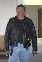
This is a picture of John G., a good friend of mine. We were riding in the area a year or so ago. This is at the Ponca Access Point.

Across the road from the entrance to the access point is an old cabin with out buildings. Its a historical spot and a good place to stop, look around and take a few pics. I'm sure I've posted pics of the cabin in the past but I can't seem to find the posting.

I rode on into Ponca. There was'nt much going on there, actually there was nothing going on there. I saw no one in town. After I left Ponca, I took Hwy 74 back to Jasper and then Hwy 7 South to home. All in all it was a wonderful, fantastic, great, slow day of riding and mind healing. Like I've said before, riding is my meditation, I tried Yoga, I like riding better.

Below is a video of the ride out of Ponca. My camera battery died just when I was reaching the Steel Creek Access Point. Please, turn down your sound, I promise I'll fix this problem if I have to JB Weld the Mic.

Friday, September 12, 2008

The Ride, Part 6

When I departed Berryville, I rode up Hwy 21 North. On the way I passed Cosmic Caverns, someday I'm going to go for the tour http://www.cosmiccavern.com . I couldn't get the link to work at my job, maybe it'll work at home. I passed up Hwy 311 at Oak Grove, I would be coming back to it. I went on North to Blue Eye,AR-MO. As far as I could tell by looking at the map, Blue Eye and Mammoth Springs (in NE Ar.) are the only two towns in Northern Arkansas that share the border of both Ar. and Mo.

Blue eye has a nice little city park, very shaded with a pizza parlor across the street. Good place to stop and have a pizza pic nic.


Cindy on the Arkansas side.
After leaving Blue Eye, I doubled back to Oak Grove where I took Hwy 311 South at the intersection. Somewhere on this absolutely beautiful ride was the community of Farewell. I remember seeing two houses and a barn. Don't bother looking for it on the map, its not there.

After arriving at Green Forest, I made a right on Hwy 62, retracing my earlier route to Berryville. Only this time I made a turn South on Hwy 21. I followed 21 to the T and made a right on Hwy 412 then an almost immediate left to get back on Hwy 21.

This was an old barn getting taking over by nature on the outskirts of Kingston.
A view of downtown Kingston looking West from the county road that enters the square. I like this town alot, its seems slow and quiet. I saw young people hanging out at the gazebo and others just walking around and riding bicycle. The last time I rode through here, probably a couple of years ago, there was an old wooden gas station store with probably two gas pumps. I like that in small towns, I like keeping everything just as it is for as long as possible.

Kingston didn't keep things as they were, maybe the old building was deteriorating. Kingston now has a brand new station with lots of pumps, a store with hot food, and a car wash. The good part is that it is a little ways from the town center and it has an outside table which looks like it was put there just for bikers. In the picture below, the new station is straight up Hwy 21 which is to the left of the big white building in the picture below.

Another view of Kingston. Kingston has a large city square with a gazebo in the center of it. Two Highways and a county road converge here and there are white arrows on the pavement giving you directions. You can barely see the white arrow in front of me telling me I should go counter clockwise in the square. In this pic I am sitting where Hwy 74 comes into the square, I'm facing North. Directly in front of me is Hwy 21 which I rode in on. To my right out of the picture is where 21 goes up Kingston Mountain.
Somewhere in that direction on a steep hillside along Hwy 21 is a little cabin. Unless it has burned down. I went there probably 6 years ago without a camera. Supposedly its a cabin that belonged to one of the first inhabitants of Kingston. I'll go back and take another look later. I didn't see it this ride and was trying to make it home before dark, so I didn't doubleback and look for it.

After reaching Boxley I made a left North on 43 which will take me to Ponca for the last tail of this ride. I'll do that tomorrow.

Thursday, September 11, 2008

The Ride, Part 5

Across from the Marble Monument is Dogpatch USA, the old theme park. I think it closed sometime in the mid 80's.
One of Dogpatch's waterfalls.
One of the old buildings.

Alot of good memories from Dogpatch. I went there several times while it was still in operation.

After taking a few pictures I rode North again. About 7 miles South of Harrison I took a left onto Hwy 206, then 397,392 and eventually 62 West to Berryville.

Don't miss Saunders Museum in Berryville. http://www.berryville.com/museum.html
This is a museum in Berryville and I think its the old courthouse, don't quote me on that though.
Another interesting building in Berryville seen from the town square. Berryville has a nice town square with fountains, pic-nic tables, gazebo's and lots of shade.


The Carroll County Veterans Memorial in the square at Berryville.

Wednesday, September 10, 2008

The Ride, Part 4 " I like Jasper"

After leaving Round Top Mountain, I rode North towards Jasper.

Newton County was having the Fair on the mountain South of town.
Riding into Jasper, there wasn't much traffic even though it was a wonderful day.
Passing on through town, I was slowed by a farm tractor.
I stopped off at the Wildlife Museum on the left going North out of Jasper. I can't remember what its called. It's worth the stop though, if you have any interest in outdoors stuff. They had some really good outdoors displays, including an old enforcement officer uniform and other items.
Somehow though, I just couldn't understand the fairly large display of drug enforcement pictures (I know, I know this is the Federal Government and they are proud of their pot cutting trips. Even though it is a total waste of tax payer dollars). I believe when children are brought into the museum they should see outdoor displays, not to include drugs. There's some big time corruption and money being made somewhere in this weed erradication project. I would bet my sweet bippy on that. Uh Oh, I said that. I'll be sure and flog myself later for being the bad person.
After the Museum, I rode on towards Harrison. The bicyclers were out enjoying the good weather.
I came to a Historical Marker sign and pulled over to take a look. On the side of the hill was a monument, almost overgrown with weeds. The first time I read the inscription, I thought this was really cool. I wondered why don't take better care of such an important marker. It's seems important to me. This is the spot where "Beller and Harp Bros." dug up Arkansas's Marble contribution to the Washington Monument. Am I reading too much into this, am I making a mountain out of a molehill? To me this is an important site. It deserves a little more than what it got. Was Beller and Harp Bros. a company? Was it a group of brothers? If it was brothers, was there family that lived in the area. How about they tell us that. Am I asking too much? There's no story about the men that picked it up, how they did it or what time of the year it was. There's a creek called Harp Creek not far from here, Arkansas Hwy 7 crosses over it, was the creek named after one of the Brothers that picked up the Marble.
Double click the pic and you can read the inscription. You can let your breath out now, I know you must couldn't wait for the real story of the Arkansas marble in the Washington Monument. So here it is, just click below.

http://users.aristotle.net/~russjohn/washmon.html

Across from this monument is a place that at one time was the tourist mecca of the Arkansas Ozarks. I'll get back on the Ride there in Part 5.

Tuesday, September 9, 2008

Cindy is 50,000 Miles old !!!!!!

Part 3 of The Ride will just have to wait.

Today was the big day. I knew I only had a short distance to reach 50 k on Cindy so I went for a ride to mark the occasion.

The 50 k ride was not without a moment or two to reflect on.
It was a beautiful day for riding. Overcast, a slight chance of rain and just cool enough to wear my leather jacket, which I like to do for safety. Also it was windy and the heavy leather keeps my shirt from flapping in the wind.
About a quarter mile from my house. A cable van coming towards me barely escaped hitting a deer. At he end of my ride and about five miles from home a deer ran in front of my bike, a big deer. When I got home and stopped, a deer crossed my field within 50 yards of me. This was a good day for deer, they love these kind of days, if the wind was to die down a little it would be a perfect day for deer to move around
I passed through Atkins on the way. I like their Military Memorials. Speaking of that...You can see more at my new blog. http://www.militarymemorials.blogspot.com/ Its getting close to the anniversary of 9-11.
Did you know that Morrilton has a small museum at their train depot?
This is the Conway County Library at Morrilton which was built in 1916 and is on the National Register of Historic Places.
Morrilton had a Congressional Medal of Honor recipient. This Momument is to the side of the Library. Nathan Gordon served 20 years as Lt. Gov. of Arkansas. He died Sept. 9, 2008, he was 92.
The big moment.
I was about a quarter mile from here when it happened. This is VFW Post 4453 in Morrilton.
I started having problems with my starter about 600 miles ago. I guess its the usuall, a bad stater. I know nothing of these things, only what I hear but it sounds like Cindy's going to have an operation soon. I'm going to try and make it to BBBQ before I put her in the shop. I think she'll make it. I'm sure I'll have some problems starting her, but I'm not gonna miss the BBBQ.
I'll park on hills or something. I kind of figured that something would happen at around 50 k.

Sunday, September 7, 2008

The Ride, Part 3

After traveling Hwy 374 and arriving at Hwy 7, I was just South of the tourist Lookout with the view of Arkansas's Grand Canyon, which is the Buffalo River valley.
Not too far past the Lookout is the Round Top Mountain Hiking Trail sign on the left. Its a dirt road and fairly steep so be careful cruiser riders. There is an outdoor restroom, pamphlets and a picture of the trail carved in Cedar.

This trail is a 4 mile round trip. You can find fossil remains along the trail and evidence the area was once inhabited by Ozark Bluff Dwellers. The most obvious being a bluff shelter with flint chips , ash in the soil and fire blackened rock.

The trail also has the remains of a tragic accident. On February 6, 1948 on a foggy cold night, a B-25 bomber crashed into the side of the mountain killing all five of its military passengers.
The crash site has been marked with a memorial honoring those men. An engine and some small debris remain as a reminder of that tragic event.

Its a nice spot to stop at, just be careful, if your not watching for it you can pass it up easy.

Above is part of the parking area.
There are restrooms behind this building.
The map, carved in wood. There are also pamphlets at the building.
Part of one of the engines off the B-25 that crashed here in 1948.